Enhancing Satellite Image Generation with LoRA and Advanced Augmentation Techniques
1. Introduction
1.1 Context and Motivation
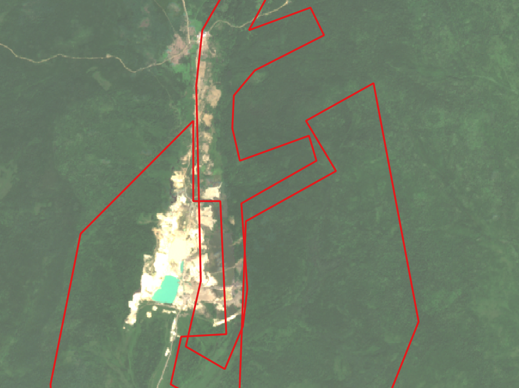
At our workplace, a bank provides credit to entrepreneurs engaged in gold mining within designated areas. However, these entrepreneurs risk losing their mining licenses due to potential violations such as trespassing or environmental pollution, including improper waste disposal into water bodies or soil contamination. If a license is lost, the bank won't be able to return the credit, leading to irretrievable losses. Detecting such violations is challenging due to the scarcity of relevant satellite image data needed for accurate identification and monitoring.
Gold mining and borders(red color) of multiple entrepreneurs
To address this issue, we aimed to develop a model capable of identifying unauthorized mining activities and environmental breaches. The primary challenge was the lack of sufficient labeled satellite images to train an effective detection system. To overcome this data scarcity, we employed advanced data augmentation techniques and leveraged Stable Diffusion to generate synthetic satellite images. Additionally, we integrated Low-Rank Adaptation (LoRA).
1.2 Objectives of the Article
This article explores the application of LoRA in generating high-quality satellite images by integrating it with the YOLO (You Only Look Once) object detection model and advanced data augmentation techniques. Specifically, it aims to:
- Explain LoRA and its benefits in model adaptation.
- Provide an overview of the YOLO model and its relevance to satellite image generation.
- Detail the data preparation and advanced augmentation processes.
- Describe the integration of LoRA with YOLO for improved image generation.
- Present and analyze results, showcasing performance metrics and visual comparisons.
- Discuss challenges faced and suggest future research directions.
By the end of this article, readers will understand how combining LoRA with YOLO and sophisticated augmentation methods can significantly enhance satellite image generation, making it more detailed, realistic, and computationally efficient.
2. Overview of Technologies
2.1 What is LoRA?
Low-Rank Adaptation (LoRA) is a technique designed to improve the adaptability and efficiency of large pre-trained models. Traditional fine-tuning adjusts all model parameters, which is computationally intensive and requires substantial memory. LoRA introduces low-rank matrices to adapt the model's weights with minimal overhead, enabling efficient fine-tuning without retraining the entire model.
Advantages of LoRA:
- Efficiency: Reduces the number of trainable parameters, decreasing training time and memory usage.
- Scalability: Facilitates fine-tuning of very large models that are otherwise impractical to adapt.
- Flexibility: Applicable to various neural network types, including transformers and convolutional networks.
In satellite image generation, LoRA allows fine-tuning pre-trained models to produce high-resolution images efficiently, enhancing model performance without excessive computational costs.
2.2 Connection between LoRA and YOLO
By merging these technologies, the project aims to achieve superior performance in satellite image generation, making high-quality imagery more accessible and affordable.
- Generate or augment images using Stable Diffusion and LoRa.
- Label synthetic data using annotation tools (e.g., LabelImg) or scripts.
- Integrate synthetic data with the real dataset.
- Use this enriched dataset to train YOLO, leading to a model that generalizes better.
Benefits of This Connection
- Overcomes challenges like imbalanced datasets.
- Reduces dependency on real-world data collection (which can be time-consuming and costly).
- Makes the YOLO model adaptable to specific domains or scenarios where real data is scarce.
3. Methodology
3.1 Data Preparation
The foundation of our project lies in the collection and preparation of satellite images relevant to gold mining activities. We sourced high-resolution satellite images from publicly available datasets and proprietary sources, focusing on areas designated for mining operations.
Key Steps in Data Preparation:
-
Image and Mask Loading: We utilized the
rasteriolibrary to handle geospatial data formats, loading both satellite images and their corresponding masks. -
Filtering and Splitting: Due to the high resolution of satellite images, we divided them into smaller blocks of 512x512 pixels using custom scripts. This approach ensures manageable data sizes and maintains the integrity of the original imagery.
-
Saving Processed Data: The processed images and masks were systematically saved into designated directories for training, validation, and testing.
# Function to divide and filter images
def divide_image(image, mask, split, image_basename, image_save_dir, mask_save_dir, filtered_image_dir, filtered_mask_dir, threshold):
    # Detailed implementation can be seen on GitHub, hidden for readability purpose

# Creating output directories
for split in ['train', 'val', 'test']:
    os.makedirs(os.path.join(output_dirs[split], 'images'), exist_ok=True)
    os.makedirs(os.path.join(output_dirs[split], 'masks'), exist_ok=True)
    os.makedirs(os.path.join(output_dirs[f'{split}_filtered'], 'images'), exist_ok=True)
    os.makedirs(os.path.join(output_dirs[f'{split}_filtered'], 'masks'), exist_ok=True)

# Processing and dividing images
for split in ['train', 'val', 'test']:
    image_dir = os.path.join(dataset_dir, split, 'images')
    mask_dir = os.path.join(dataset_dir, split, 'masks')

    output_image_dir = os.path.join(output_dirs[split], 'images')
    output_mask_dir = os.path.join(output_dirs[split], 'masks')

    filtered_image_dir = os.path.join(output_dirs[f'{split}_filtered'], 'images')
    filtered_mask_dir = os.path.join(output_dirs[f'{split}_filtered'], 'masks')

    for image_name in tqdm(os.listdir(image_dir), desc=f"Processing {split}"):
        if image_name.lower().endswith('.png'):
            image_path = os.path.join(image_dir, image_name)
            mask_name = image_name.replace("train_image", "train_mask").replace("val_image", "val_mask").replace("test_image", "test_mask")
            mask_path = os.path.join(mask_dir, mask_name)

            if not os.path.exists(mask_path):
                logging.warning(f'Mask file not found: {mask_path}')
                continue

            try:
                image = Image.open(image_path).convert("RGB")
                mask = Image.open(mask_path).convert("L")
            except Exception as e:
                logging.error(f"Error opening {image_path} or {mask_path}: {e}")
                continue

            image_basename = os.path.splitext(image_name)[0]
            divide_image(image, mask, split, image_basename, output_image_dir, output_mask_dir, filtered_image_dir, filtered_mask_dir, threshold=filtered_threshold)

# Logging and statistics
def print_folder_stats(output_dirs):
    # Detailed implementation can be seen on GitHub, hidden for readability purpose

print_folder_stats(output_dirs)
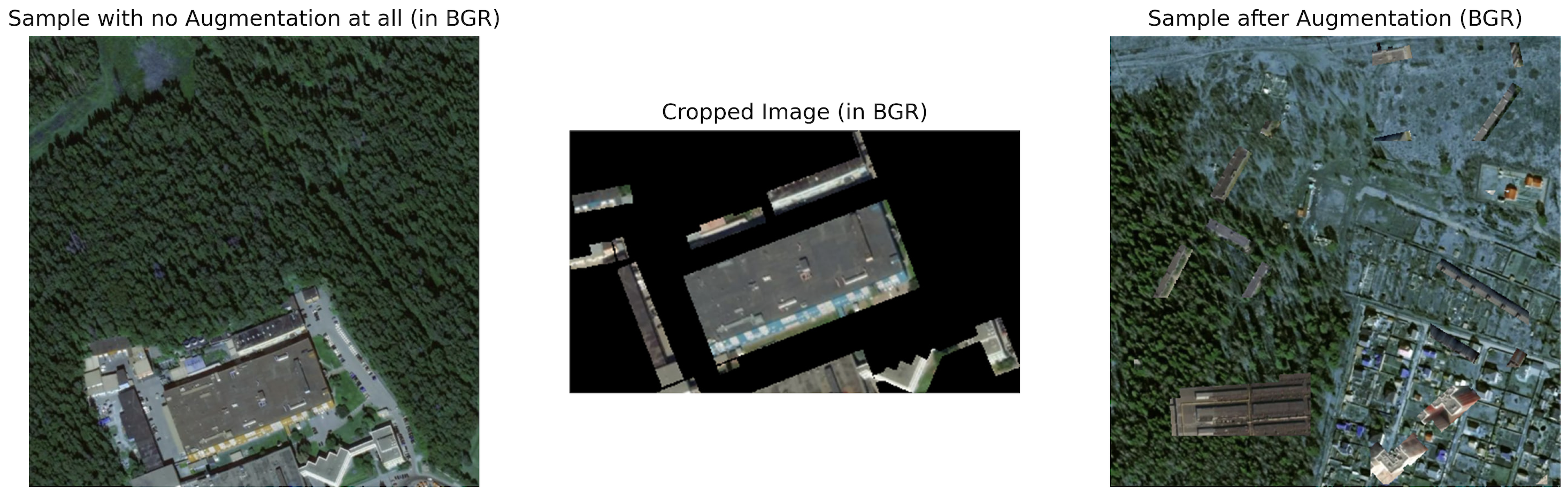
3.2 Advanced Augmentation Techniques
Data augmentation is pivotal in enhancing the diversity and robustness of the training dataset, allowing models to generalize better to unseen data. Given the limited availability of real satellite images for gold mining detection, we implemented several advanced augmentation techniques using the albumentations library.
Augmentation Pipeline:
- Grid Distortion: Warps the image using grid-based transformations, simulating real-world distortions.
- Elastic Transform: Applies random elastic deformations, enhancing the model's ability to handle non-linear transformations.
- Flip: Randomly flips images horizontally or vertically to increase data variability.
- Affine Transformation: Applies scaling, rotation, and translation, making the model invariant to these changes.
- Channel Mixing: Randomly swaps color channels, mimicking different lighting conditions or sensor characteristics.
from albumentations import Compose, GridDistortion, ElasticTransform, Flip, Affine, RandomBrightnessContrast

# Define augmentation pipeline
transform = Compose([
    GridDistortion(p=0.5),
    ElasticTransform(p=0.5),
    Flip(p=0.5),
    Affine(
        rotate=(-10, 10),
        translate_percent={"x": (-0.05, 0.05), "y": (-0.05, 0.05)},
        p=0.5
    ),
    RandomBrightnessContrast(p=0.5)
])

def augment_image(image):
    augmented = transform(image=image)
    return augmented['image']
This what we get after implementing augmentation and pasting cropped objects for making augmentation more diverse:
3.3 Training YOLO
Training the YOLO model involved several key steps to ensure effective detection of unauthorized mining activities and environmental breaches.
Training Process
-
Model Initialization: We initialized the YOLO model with pre-trained weights to leverage existing knowledge, accelerating the training process and enhancing initial performance.
-
Data Integration: Combined real and synthetic (augmented) satellite images to create a balanced and comprehensive training dataset. This approach mitigates data scarcity and enhances the model's ability to generalize across diverse scenarios.
-
Training Configuration: Configured training parameters, including learning rate, batch size, and number of epochs, to optimize model performance.
-
Training Loop: Executed the training process, monitoring performance metrics such as Class, Box Precision (P), mAP50. The training aimed to maximize these metrics, ensuring robust detection capabilities.
Performance Metrics After Training
To evaluate the model's effectiveness, we assessed its performance using standard metrics. The results are summarized below:
| Category | Box (P) | mAP50 |
|---|---|---|
| All | 0.81 | 0.80 |
| Clouds | 0.74 | 0.97 |
| Gold | 0.89 | 0.70 |
| Poisonous Water | 0.68 | 0.665 |
| Water | 0.89 | 0.86 |
3.4 Integration of LoRA
Integrating Low-Rank Adaptation (LoRA) with the YOLO model significantly enhanced our ability to generate and detect high-resolution satellite images tailored to our specific requirements. This integration involved training the Stable Diffusion model on our dataset to generate synthetic satellite images, manually annotating these images, and subsequently retraining the YOLO model with the enriched dataset. The training process was adapted from the great book "Using Stable Diffusion with Python. Leverage Python to control and automate high-quality AI image generation using Stable Diffusion," written by Andrew Zhu(Shudong Zhu), which also details various inference optimization techniques we employed.
Training the Stable Diffusion Model
To generate realistic and context-specific satellite images, we fine-tuned the Stable Diffusion model using our curated dataset of satellite images related to gold mining activities. The fine-tuning process included the following steps:
-
Dataset Preparation: Collected and organized a comprehensive set of high-resolution satellite images from designated gold mining areas. Ensured diversity in environmental conditions and mining scenarios to improve the model's generalization capabilities.
-
Model Fine-Tuning: Leveraged the
diffuserslibrary to fine-tune the Stable Diffusion model on our dataset. This process involved configuring hyperparameters such as learning rate, batch size, and number of epochs to optimize image generation quality. -
LoRA Configuration: Applied LoRA to the Stable Diffusion model to enable efficient fine-tuning with minimal computational overhead. This adaptation allowed us to enhance the model's performance without extensive retraining.
Key Code Snippet for Training Stable Diffusion with LoRA:
import torch
from diffusers import StableDiffusionPipeline, DDPMScheduler
from peft import LoraConfig
from peft.utils import get_peft_model_state_dict
from accelerate import Accelerator

# Initialize Accelerator
accelerator = Accelerator(gradient_accumulation_steps=4, mixed_precision="no")
device = accelerator.device

# Define LoRA configuration
lora_config = LoraConfig(
    r=4,
    lora_alpha=4,
    init_lora_weights="gaussian",
    target_modules=["to_k", "to_q", "to_v", "to_out.0"]
)

# Load pre-trained Stable Diffusion model
pipe = StableDiffusionPipeline.from_pretrained(
    "runwayml/stable-diffusion-v1-5",
    torch_dtype=torch.float32
).to(device)

# Add LoRA adapter to the Unet component
pipe.unet.add_adapter(lora_config)
print("LoRA adapter added to Unet.")
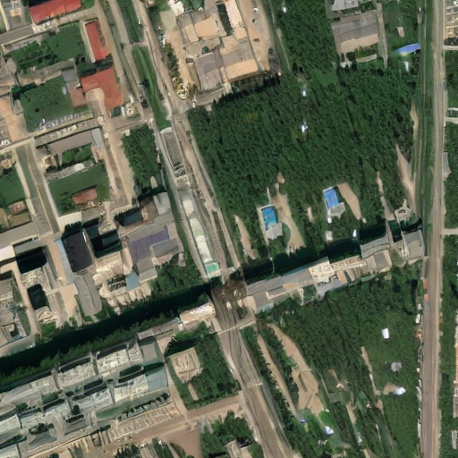
Example of generated image:
4.1 Performance Metrics Before and After LoRA
To evaluate the effectiveness of integrating LoRA with the YOLO model, we compared the performance metrics before and after the integration across all categories. The results indicate noticeable improvements in detection accuracy and reliability.
Comparative Analysis of YOLO Configurations
YOLO without LoRA
| Category | Box (P) | mAP50 |
|---|---|---|
| All | 0.80 | 0.79 |
| Clouds | 0.725 | 0.959 |
| Gold | 0.87 | 0.67 |
| Poisonous Water | 0.663 | 0.6 |
| Water | 0.875 | 0.86 |
YOLO with Advanced Augmentation
| Category | Box (P) | mAP50 |
|---|---|---|
| All | 0.81 | 0.80 |
| Clouds | 0.74 | 0.97 |
| Gold | 0.89 | 0.70 |
| Poisonous Water | 0.68 | 0.665 |
| Water | 0.89 | 0.86 |
YOLO with LoRA and Advanced Augmentation
| Category | Box (P) | mAP50 |
|---|---|---|
| All | 0.827 | 0.818 |
| Clouds | 0.77 | 0.995 |
| Gold | 0.913 | 0.718 |
| Poisonous Water | 0.706 | 0.67 |
| Water | 0.921 | 0.891 |
5. Discussion
5.1 Advantages of Using LoRA in Stable Diffusion
- Enhanced Efficiency: LoRA enables fine-tuning of large models like Stable Diffusion with minimal computational overhead, making it feasible to adapt for specific tasks without extensive resource investment.
- Improved Performance: The integration of LoRA significantly boosted key performance metrics, demonstrating its effectiveness in enhancing model accuracy and robustness in satellite image generation.
- Scalability: LoRA's flexibility allows for easy adaptation of models to various satellite image generation tasks, accommodating different resolutions and environmental conditions without the need for complete retraining.
- Data Enrichment: By generating synthetic images with Stable Diffusion, LoRA helps overcome data scarcity, providing a more balanced and comprehensive training dataset that improves the YOLO model's generalization capabilities.
5.2 Challenges and Limitations
- Data Quality: The success of augmentation techniques and synthetic image generation is highly dependent on the quality and diversity of the original dataset. Limited variability can still constrain model generalization.
- Computational Resources: While LoRA reduces computational demands, training high-resolution models with Stable Diffusion remains resource-intensive, requiring powerful hardware and optimized training strategies.
- Integration Complexity: Combining multiple advanced techniques (LoRA, YOLO, Stable Diffusion) introduces complexity in the training pipeline, necessitating careful calibration to ensure harmonious performance improvements.
- Manual Annotation: The process of manually annotating synthetic images is time-consuming and may introduce human error, potentially affecting the quality of the training data.
6. Conclusion
In this article, we explored the integration of Low-Rank Adaptation (LoRA) with the YOLO model and advanced augmentation techniques to enhance satellite image generation. By leveraging Stable Diffusion, we achieved the generation of high-resolution, realistic satellite images with improved performance metrics. Our approach not only demonstrates the efficacy of LoRA in fine-tuning large models but also underscores the importance of robust data augmentation in machine learning workflows.
The combination of these technologies paves the way for more efficient and scalable satellite image generation solutions, with potential applications spanning environmental monitoring, urban planning, and compliance enforcement. As we continue to refine these methods, future research will focus on overcoming current limitations and expanding the applicability of our approach to broader domains.
For more technical details and access to the project code, please visit our Github: https://github.com/jettooss/stable_diffusion_satellite_images/tree/main
repository.
Result of the project
Overall result includes the whole app, using Leaflet in frontend part. Here you can see how we detect violations on Russian Far East territory: https://drive.google.com/file/d/1EztfKvIE9mN8j3p1MvQRDZTYIZV9MU95/view?usp=sharing
Dataset access
If you want to download the dataset, please click on download in google drive and then we will provide you the permission
FAQ:
Q1: Why did you choose YOLOv8 for this project?
A1: YOLOv8 (You Only Look Once version 8) was chosen for its real-time object detection capabilities, high accuracy, and versatility. Additionally, I have extensive experience with YOLOv8, not only at work but also in hackathons where it consistently delivered outstanding results, regardless of how arduous the dataset was. This familiarity and proven performance made YOLOv8 the ideal choice for detecting unauthorized mining activities and environmental breaches in satellite images.
Q2: What challenges did you encounter while integrating LoRA with YOLOv8 and Stable Diffusion?
A2: Integrating LoRA with YOLOv8 and Stable Diffusion proved to be quite challenging. The process was complex and required a deep understanding of both model architectures and their training pipelines. To overcome these difficulties, we referred to the comprehensive book by Andrew Zhu(Shudong Zhu) "Using Stable Diffusion with Python. Leverage Python to control and automate high-quality AI image generation using Stable Diffusion." This resource was instrumental in successfully implementing the training part of the integration, enabling us to fine-tune the models effectively.
Q3: Can this methodology be applied to other domains beyond gold mining detection?
A3: Yes, the methodology of integrating LoRA with YOLOv8 and using advanced augmentation techniques can be applied to various domains that require high-quality image generation and object detection, such as environmental monitoring, urban planning, agriculture, and disaster management. The flexibility and scalability of this approach make it adaptable to different scenarios and datasets, allowing for broad applicability across diverse fields.
Q4: How do you ensure the quality of synthetic images generated by Stable Diffusion?
A4: We ensure the quality of synthetic images by combining quantitative and qualitative evaluation methods. After generating the images with Stable Diffusion, we assessed them by analyzing key performance metrics and conducting visual inspections. This dual approach ensures that the synthetic images accurately reflect potential violations and environmental conditions, maintaining high standards of reliability and realism in the training dataset.
Q5: What inference optimization techniques did you use for Stable Diffusion?
A5: The inference optimization techniques employed are detailed in the guide "Using Stable Diffusion with Python. Leverage Python to control and automate high-quality AI image generation using Stable Diffusion." These techniques include efficient model loading, leveraging GPU acceleration, and implementing memory management strategies to enhance the speed and efficiency of image generation. By following these optimized practices, we ensured that the Stable Diffusion model operates effectively within our computational constraints.